Chapter 6.5 - The `<area>` Element
Complete HTML reference for the area element, including syntax, attributes, DOM interface, browser behavior, accessibility, SEO, JavaScript integration, and best practices.
Chapter 6 — Multimedia and Interactive Graphics
6.5 The <area> Element
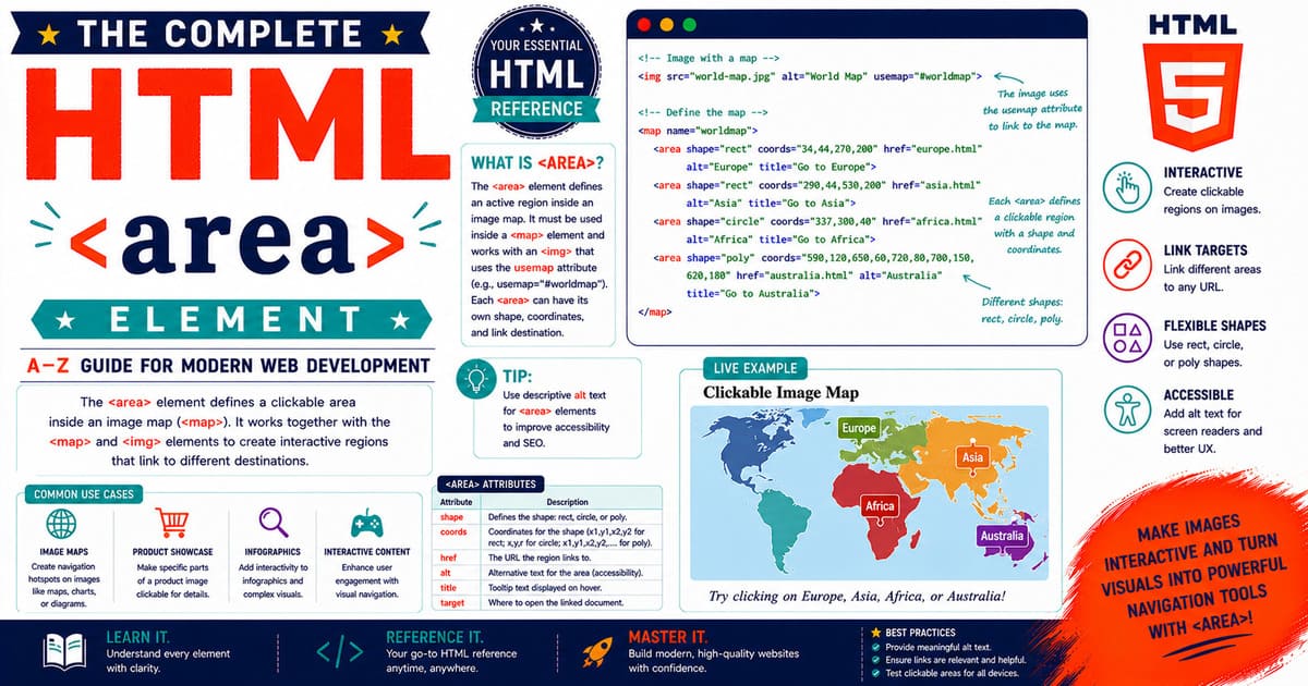
The <area> element defines a clickable region, commonly known as a hotspot, within an image map. It works together with the <map> element to allow different parts of a single image to perform different actions.
Unlike many HTML elements, the <area> element cannot exist independently. It is only valid when used inside a <map> element, which is itself associated with an <img> element through the usemap attribute.
Although its purpose is specialized, the <area> element remains part of the HTML Living Standard and is widely supported by modern browsers.
Why the <area> Element Exists
Suppose a website displays a world map.
Instead of dividing the map into several separate images, developers can keep it as one optimized image and define individual hotspots for each continent.
Each hotspot becomes an <area> element.
Examples include:
- Countries
- Continents
- Human anatomy
- Product diagrams
- Building floor plans
- Circuit boards
- Machine components
- Museum layouts
Using <area> keeps the HTML cleaner and reduces the number of image resources required.
HTML Living Standard Definition
According to the HTML Living Standard, the <area> element represents either:
- A hyperlink, when the
hrefattribute is present. - A placeholder region, when no
hrefattribute is provided.
Each <area> belongs to an image map and defines one interactive region.
Parent Element
The <area> element is permitted only inside a <map> element.
Correct structure:
1
2
3
4
5
6
7
8
9
10
11
12
13
14
<img
    src="world-map.jpg"
    alt="World Map"
    usemap="#world">

<map name="world">

    <area
        shape="rect"
        coords="50,40,180,160"
        href="asia.html"
        alt="Asia">

</map>
The browser associates the hotspot with the displayed image.
Content Model
The <area> element is a void element.
It contains no child elements and no closing tag.
Correct:
1
2
3
4
5
<area
    shape="circle"
    coords="200,140,60"
    href="earth.html"
    alt="Earth">
Incorrect:
1
2
3
<area>

</area>
Because it is a void element, a closing tag must never be used.
DOM Interface
The browser exposes every <area> element through the HTMLAreaElement interface.
This interface provides access to all attributes, allowing JavaScript to inspect and modify hotspots dynamically.
Examples include:
- Reading coordinates
- Updating destinations
- Changing alternative text
- Responding to user interaction
The DOM interface makes image maps fully scriptable.
Technical Characteristics
| Property | Value |
|---|---|
| Category | Flow-related image map component |
| End Tag | Forbidden |
| Closing Tag | Not permitted |
| Parent | <map> |
| Children | None |
| DOM Interface | HTMLAreaElement |
Relationship with Other Elements
The <area> element works together with several related HTML elements.
1
2
3
4
5
6
7
8
9
10
<img>
   │
   │ usemap
   ▼
<map>
   │
   ├── <area>
   ├── <area>
   ├── <area>
   └── <area>
Together these elements create an interactive image map.
Browser Processing Overview
When the browser encounters an image map, it performs these steps:
- Parse the
<img>element. - Read the
usemapattribute. - Locate the matching
<map>element. - Parse every
<area>element. - Build hotspot regions.
- Wait for user interaction.
- Execute the associated action.
This processing occurs automatically without requiring JavaScript.
Typical Use Cases
The <area> element is commonly used in:
- Educational websites
- Geography lessons
- Technical documentation
- Interactive product catalogs
- Engineering diagrams
- Medical illustrations
- Museum guides
- Tourism websites
- Manufacturing documentation
Although image maps are specialized, they remain valuable for visual learning experiences.
Advantages
Using <area> provides several benefits.
- Multiple links inside one image
- Standards-compliant implementation
- Easy maintenance
- Reduced image duplication
- Interactive user experience
- Excellent browser support
Limitations
Developers should also understand its limitations.
- Cannot exist outside
<map> - Coordinates require careful planning
- Responsive layouts require additional attention
- Complex diagrams may require many hotspot definitions
Understanding these limitations helps developers choose the appropriate solution for each project.
Practical Example
Imagine an interactive diagram of a computer motherboard.
Each hardware component is represented by an individual <area> element.
Selecting the CPU socket displays installation instructions.
Selecting a memory slot displays RAM compatibility information.
Selecting the storage connector explains supported devices.
The user explores the entire diagram without loading multiple pages.
Pro Tip
Think of the <area> element as an invisible hyperlink placed on top of a specific part of an image. The hotspot itself is not visible, but it responds to user interaction based on its defined shape and coordinates.
Common Mistakes
Mistake 1
Using an <area> element outside a <map>.
Mistake 2
Adding a closing </area> tag.
Mistake 3
Forgetting to associate the <map> with an <img> element using the usemap attribute.
Mistake 4
Leaving the alt attribute empty when the hotspot conveys important information.
Accessibility Note
Each clickable region should have meaningful alternative text. Users of screen readers rely on these descriptions to understand the purpose of each hotspot.
SEO Note
Image maps should enhance well-written content, not replace it. Surround diagrams with descriptive text and headings so search engines and users both understand the purpose of the interactive image.
Summary
In this introductory section, you learned:
- What the
<area>element is. - Why it exists.
- Where it can be used.
- Its relationship with
<map>and<img>. - Its DOM interface.
- Browser processing.
- Advantages and limitations.
Coming Up Next — Section 6.5.2
The next section explores:
- Complete attribute reference
- Required and optional attributes
- Global attributes
- Event attributes
- DOM properties
- HTMLAreaElement API
- Browser behavior
6.5.2 Complete Attribute Reference, DOM Interface, and Browser Behavior
The <area> element supports several HTML attributes that define how a hotspot behaves within an image map. Some attributes control navigation, while others improve accessibility, privacy, security, or integration with JavaScript.
This section examines every important attribute in detail.
Attribute Overview
| Attribute | Purpose | Required |
|---|---|---|
alt | Alternative text describing the hotspot | Yes* |
coords | Specifies the hotspot coordinates | Usually |
download | Downloads the linked resource | No |
href | Destination URL | No |
hreflang | Language of the linked resource | No |
ping | Sends POST requests after activation | No |
referrerpolicy | Controls referrer information | No |
rel | Relationship between documents | No |
shape | Defines the hotspot geometry | Usually |
target | Specifies where to open the destination | No |
*When an
<area>acts as a hyperlink (hrefis present), meaningful alternative text should always be provided for accessibility.
The alt Attribute
The alt attribute provides a text description of the hotspot.
Example:
1
2
3
4
5
<area
    shape="circle"
    coords="220,180,45"
    href="earth.html"
    alt="Planet Earth">
This description is used by assistive technologies and helps users understand the destination of the hotspot.
Good Examples
1
2
3
4
Asia
Download User Manual
Motherboard CPU Socket
Human Heart
Poor Examples
1
2
3
4
Click Here
Area 1
Region
Button
Descriptive text is always preferred.
The coords Attribute
The coords attribute specifies the position and size of the clickable region.
Its format depends on the selected shape.
Examples:
Rectangle:
1
2
3
4
5
<area
    shape="rect"
    coords="40,60,260,180"
    href="asia.html"
    alt="Asia">
Circle:
1
2
3
4
5
<area
    shape="circle"
    coords="300,180,70"
    href="earth.html"
    alt="Earth">
Polygon:
1
2
3
4
5
<area
    shape="poly"
    coords="40,50,140,30,220,100,180,220,70,200"
    href="country.html"
    alt="Country">
Coordinate systems were discussed in detail in Chapter 6.4 — The <map> Element.
The shape Attribute
The shape attribute defines how the browser interprets the coordinate values.
Valid values:
1
2
3
4
rect
circle
poly
default
Example:
1
2
3
4
5
<area
    shape="rect"
    coords="40,60,260,180"
    href="lesson.html"
    alt="Lesson">
Each shape is optimized for different types of diagrams.
The href Attribute
The href attribute specifies the destination.
Example:
1
2
3
4
5
<area
    shape="circle"
    coords="220,180,45"
    href="earth.html"
    alt="Earth">
Possible destinations include:
- HTML documents
- PDF files
- Images
- Email addresses
- Telephone numbers
- Fragment identifiers
- External websites
If href is omitted, the hotspot does not function as a hyperlink.
The target Attribute
The target attribute specifies where the linked resource opens.
Common values:
| Value | Description |
|---|---|
_self | Current browsing context |
_blank | New tab or window |
_parent | Parent browsing context |
_top | Top-level browsing context |
Example:
1
2
3
4
5
6
7
<area
    shape="rect"
    coords="20,40,180,160"
    href="guide.html"
    target="_blank"
    rel="noopener noreferrer"
    alt="Guide">
For security, use rel="noopener noreferrer" whenever appropriate with _blank.
The rel Attribute
The rel attribute describes the relationship between the current page and the linked resource.
Example:
1
2
3
4
5
6
7
<area
    href="https://example.com"
    target="_blank"
    rel="noopener noreferrer"
    shape="rect"
    coords="20,20,180,160"
    alt="Example">
Common values include:
noopenernoreferrernofollowexternallicense
The download Attribute
The download attribute requests that the linked resource be downloaded instead of displayed.
Example:
1
2
3
4
5
6
<area
    shape="rect"
    coords="30,40,220,170"
    href="manual.pdf"
    download
    alt="Download Manual">
The final behavior depends on browser support and server configuration.
The hreflang Attribute
The hreflang attribute indicates the language of the linked resource.
Example:
1
2
3
4
5
6
<area
    href="guide-fr.html"
    hreflang="fr"
    shape="rect"
    coords="40,50,200,180"
    alt="French Guide">
It provides language information but does not translate the linked content.
The ping Attribute
The ping attribute specifies one or more URLs that receive a POST request when the hyperlink is activated.
Example:
1
2
3
4
5
6
<area
    href="course.html"
    ping="https://example.com/ping"
    shape="rect"
    coords="40,60,200,180"
    alt="Course">
It is commonly used for analytics. Some browsers or privacy settings may disable this feature.
The referrerpolicy Attribute
The referrerpolicy attribute controls how much referrer information is sent with the request.
Example:
1
2
3
4
5
6
<area
    href="lesson.html"
    referrerpolicy="strict-origin-when-cross-origin"
    shape="rect"
    coords="30,50,180,160"
    alt="Lesson">
Common values include:
no-referreroriginsame-originstrict-originstrict-origin-when-cross-origin
Choose the policy that matches your application’s privacy requirements.
Global Attributes
Like most HTML elements, <area> supports global attributes.
Examples include:
idclassstylelangdirhiddentabindextitle
Example:
1
2
3
4
5
6
7
8
<area
    id="asiaRegion"
    class="continent"
    title="Asia"
    shape="rect"
    coords="40,60,260,180"
    href="asia.html"
    alt="Asia">
Event Attributes
Although modern development generally favors JavaScript event listeners, <area> also supports standard event attributes such as:
onclickonfocusonbluronkeydownonkeyuponmouseoveronmouseout
Example:
1
2
3
4
5
6
<area
    shape="circle"
    coords="220,180,45"
    href="earth.html"
    alt="Earth"
    onclick="console.log('Earth selected');">
For maintainability, attaching events using external JavaScript is recommended instead of inline event attributes.
The HTMLAreaElement Interface
In JavaScript, every <area> element is represented by the HTMLAreaElement interface.
Example:
1
const region = document.querySelector("area");
Common properties include:
altcoordsdownloadhashhosthostnamehreforiginpathnameportprotocolrelsearchshapetarget
These properties allow scripts to inspect and modify hotspots dynamically.
Browser Behavior
When the browser processes an <area> element, it typically:
- Reads the
shape. - Parses the
coords. - Calculates the hotspot.
- Associates it with the destination.
- Waits for keyboard, mouse, or touch interaction.
- Performs the requested action.
This behavior is consistent across modern browsers.
Practical Example
An online automobile manual displays an engine diagram.
Each <area> represents:
- Battery
- Alternator
- Radiator
- Air filter
- Fuse box
- Engine block
Selecting a component opens maintenance instructions or service documentation.
Pro Tip
Keep hotspot names descriptive and consistent throughout your project. Clear naming improves readability and simplifies future maintenance.
Common Mistakes
Mistake 1
Providing generic alternative text such as “Area 1.”
Mistake 2
Using incorrect coordinate values after replacing the image.
Mistake 3
Opening external pages in a new tab without an appropriate rel value.
Mistake 4
Using inline JavaScript for complex interactions.
Mistake 5
Ignoring keyboard accessibility during testing.
Accessibility Note
Every interactive hotspot should communicate its purpose through meaningful alternative text. Users navigating with assistive technologies should receive the same information available to sighted users.
SEO Note
Search engines cannot interpret image coordinates as meaningful content. Support every image map with descriptive headings, explanatory paragraphs, and relevant internal links.
Summary
In this section, you learned:
- Every major
<area>attribute. - Global and event attributes.
- The
HTMLAreaElementinterface. - Browser behavior.
- Accessibility recommendations.
- Security and privacy considerations.
Coming Up Next — Section 6.5.3
The next section explores:
- JavaScript integration
- Event handling
- Dynamic hotspot updates
- Browser APIs
- Production examples
- Performance optimization
- Testing and debugging
- Best practices
6.5.3 JavaScript Integration, Dynamic Hotspots, Testing, and Professional Implementation
The <area> element is fully integrated with the Document Object Model (DOM), allowing JavaScript to inspect, modify, and respond to hotspot interactions dynamically.
Although image maps can function without JavaScript, modern web applications often combine <area> elements with scripting to create rich, interactive user experiences.
Typical applications include:
- Interactive learning platforms
- Technical documentation
- Medical illustrations
- Geographic information systems (GIS)
- Product demonstrations
- Interactive museum guides
- Industrial equipment manuals
Accessing an <area> Element
Every <area> element can be selected using standard DOM methods.
Example:
1
2
3
4
5
6
7
8
9
10
<map name="computerMap">

    <area
        id="cpuArea"
        shape="rect"
        coords="120,80,260,190"
        href="cpu.html"
        alt="CPU">

</map>
JavaScript:
1
const cpuArea = document.getElementById("cpuArea");
The variable now references the <area> element.
Reading Properties
The HTMLAreaElement interface exposes all important properties.
Example:
1
2
3
4
5
6
7
8
9
console.log(cpuArea.alt);

console.log(cpuArea.coords);

console.log(cpuArea.href);

console.log(cpuArea.shape);

console.log(cpuArea.target);
Possible output:
1
2
3
4
5
6
7
8
9
CPU

120,80,260,190

https://example.com/cpu.html

rect

_self
These properties can be read at any time.
Modifying Properties
JavaScript can update hotspot information while the page is running.
Example:
1
cpuArea.alt = "Central Processing Unit";
Updating coordinates:
1
cpuArea.coords = "110,75,270,195";
Updating the destination:
1
cpuArea.href = "processor.html";
The browser immediately applies these changes.
Adding Event Listeners
Like other interactive HTML elements, <area> supports DOM events.
Example:
1
2
3
4
5
cpuArea.addEventListener("click", function () {

    console.log("CPU selected.");

});
Whenever the hotspot is selected, the event executes before navigation occurs.
Preventing Default Navigation
Sometimes developers want to perform an action before opening the destination.
Example:
1
2
3
4
5
6
7
cpuArea.addEventListener("click", function (event) {

    event.preventDefault();

    alert("Loading processor information...");

});
This technique is useful for displaying dialogs, animations, or confirmation messages.
Displaying Dynamic Information
Interactive diagrams often update a content panel instead of navigating to another page.
HTML:
1
<div id="componentInfo"></div>
JavaScript:
1
2
3
4
5
6
7
8
cpuArea.addEventListener("click", function (event) {

    event.preventDefault();

    document.getElementById("componentInfo").textContent =
        "The CPU executes program instructions and performs calculations.";

});
Users receive immediate feedback without leaving the current page.
Working with Multiple Hotspots
Large image maps often contain many <area> elements.
Example:
1
const hotspots = document.querySelectorAll("area");
Loop through every hotspot:
1
2
3
4
5
hotspots.forEach(function (region) {

    console.log(region.alt);

});
This approach is useful for analytics, debugging, and dynamic updates.
Dynamic Hotspot Generation
Some applications generate hotspots using JavaScript.
Typical workflow:
- Retrieve coordinate data from a database.
- Create
<area>elements. - Assign attributes.
- Insert them into the
<map>element. - Register event listeners.
This technique is useful for applications where hotspot data changes frequently.
Browser Events
Common events include:
| Event | Purpose |
|---|---|
click | User activates the hotspot |
focus | Keyboard focus enters the hotspot |
blur | Keyboard focus leaves the hotspot |
keydown | Keyboard key is pressed |
keyup | Keyboard key is released |
mouseover | Pointer enters the hotspot |
mouseout | Pointer leaves the hotspot |
Modern applications usually attach these events with addEventListener().
Integrating with CSS
The <area> element has no visible appearance and therefore cannot be styled directly.
Instead, developers highlight regions using:
- SVG overlays
- Canvas drawings
- Absolutely positioned elements
- CSS pseudo-overlays
- Tooltip components
This provides visual feedback while keeping the underlying image map intact.
Testing Image Maps
Before deployment, test every hotspot carefully.
Recommended checklist:
- Desktop browsers
- Mobile browsers
- Tablets
- Portrait orientation
- Landscape orientation
- Touch interaction
- Keyboard navigation
- Zoomed pages
- High-resolution displays
Testing ensures hotspots remain accurate and usable across devices.
Debugging Tips
If a hotspot does not work correctly:
- Confirm the
usemapattribute matches the<map>element’sname. - Verify the coordinate values.
- Ensure the image has loaded completely.
- Check for overlapping hotspots.
- Confirm that JavaScript errors are not preventing execution.
- Test with browser developer tools.
Systematic debugging helps identify issues quickly.
Performance Considerations
Image maps are lightweight by design.
To maximize performance:
- Optimize image size.
- Avoid unnecessary event listeners.
- Cache frequently used DOM elements.
- Load large datasets only when required.
- Minimize expensive coordinate recalculations.
These practices improve responsiveness, particularly on mobile devices.
Security Considerations
When hotspot information is generated dynamically:
- Validate incoming data.
- Sanitize user input.
- Use HTTPS for external links.
- Avoid executing untrusted scripts.
- Apply an appropriate Content Security Policy (CSP).
Secure coding practices help protect users and applications.
Practical Example
An online automotive repair guide displays an engine diagram.
Each hotspot represents a component:
- Engine block
- Battery
- Alternator
- Air filter
- Radiator
- Fuse box
Selecting a hotspot displays maintenance procedures, recommended tools, replacement intervals, and safety warnings without navigating away from the page.
Pro Tip
Store hotspot definitions in a structured format such as JSON when building large applications. This makes it easier to update diagrams without modifying HTML manually.
Example structure:
1
2
3
4
5
6
7
8
[
  {
    "name": "CPU",
    "shape": "rect",
    "coords": "120,80,260,190",
    "href": "cpu.html"
  }
]
This approach scales well for complex projects.
Common Mistakes
Mistake 1
Attempting to style the <area> element directly with CSS.
Mistake 2
Using inline JavaScript instead of external scripts.
Mistake 3
Ignoring touch interactions on mobile devices.
Mistake 4
Updating image dimensions without recalculating hotspot coordinates.
Mistake 5
Not testing keyboard navigation.
Accessibility Note
Interactive image maps should always have a keyboard-accessible alternative, such as a list of text links below the image. This ensures users who cannot use a pointing device can still access the same information.
SEO Note
Use descriptive captions, headings, and surrounding content to explain the purpose of an image map. Search engines rely on textual context rather than hotspot coordinates when indexing content.
Summary
In this section, you learned:
- How JavaScript interacts with the
<area>element. - Reading and modifying hotspot properties.
- Event handling.
- Dynamic hotspot generation.
- Testing and debugging techniques.
- Performance optimization.
- Security considerations.
- Professional implementation strategies.
Coming Up Next — Section 6.5.4
The final section of the <area> chapter will cover:
- Browser compatibility
- Production-ready checklists
- Accessibility checklist
- SEO checklist
- Interview questions
- Best practices
- Chapter summary
- Publishing recommendations
6.5.4 Browser Compatibility, Best Practices, Accessibility, SEO, Interview Questions, and Chapter Summary
The <area> element has been part of HTML since the early development of the World Wide Web and continues to be included in the HTML Living Standard.
Although image maps are not used as frequently as other interactive HTML features, they remain an excellent solution for educational websites, technical documentation, engineering diagrams, interactive floor plans, and geographical applications.
This final section summarizes the professional use of the <area> element and provides practical guidance for real-world projects.
Browser Compatibility
The <area> element is fully supported in all modern browsers.
| Browser | Support |
|---|---|
| Google Chrome | Yes |
| Mozilla Firefox | Yes |
| Microsoft Edge | Yes |
| Apple Safari | Yes |
| Opera | Yes |
| Android Browser | Yes |
| Safari on iOS | Yes |
The element has been supported for many years, making it a reliable choice for production websites.
Mobile Device Support
Modern smartphones and tablets fully support image maps.
However, developers should ensure that:
- Hotspots are large enough for touch interaction.
- Closely positioned hotspots do not overlap.
- Responsive layouts maintain accurate hotspot positions.
- Touch gestures do not interfere with navigation.
Always test on actual mobile devices whenever possible.
Accessibility Checklist
Before publishing an image map, verify the following checklist.
Image
- Meaningful
alttext on the<img>element. - Appropriate image description if required.
- Decorative images marked appropriately.
Hotspots
- Every
<area>has descriptivealttext. - Link destinations are clearly identified.
- Hotspots are logically organized.
Navigation
- Alternative text links are available.
- Keyboard users can access important content.
- Information is not available only through images.
Accessibility should always be considered from the beginning of the project rather than added later.
SEO Checklist
To improve search engine visibility:
- Use descriptive page titles.
- Include relevant headings.
- Explain the diagram in surrounding text.
- Add informative captions.
- Use meaningful internal links.
- Avoid placing essential content exclusively inside image maps.
Search engines primarily analyze HTML content rather than image coordinates.
Performance Checklist
For the best performance:
- Compress images.
- Choose appropriate image formats.
- Reduce unnecessary JavaScript.
- Cache static resources.
- Test page loading on slower networks.
- Keep hotspot definitions organized.
Optimizing images often has a greater performance impact than optimizing the image map itself.
Security Checklist
When linking from <area> elements:
- Use HTTPS whenever possible.
- Validate dynamically generated URLs.
- Avoid linking to untrusted websites.
- Use
rel="noopener noreferrer"withtarget="_blank"where appropriate. - Review Content Security Policy (CSP) settings.
Following these practices helps protect both users and applications.
Production Example 1 — Interactive Geography
A geography website displays a political map of the world.
Each country is represented by a hotspot.
Visitors can select a country to view:
- Capital city
- Population
- Currency
- Official language
- National flag
- Historical information
One optimized image provides access to hundreds of destinations.
Production Example 2 — Human Anatomy
A medical education platform displays an anatomical illustration.
Each organ contains a hotspot.
Students can explore:
- Structure
- Function
- Diseases
- Medical terminology
- Related animations
This creates an engaging visual learning experience.
Production Example 3 — Manufacturing Documentation
A factory maintenance manual displays a machine diagram.
Each component links to:
- Operating instructions
- Maintenance schedules
- Spare parts
- Safety precautions
- Troubleshooting guides
Engineers can quickly locate the required documentation.
Production Example 4 — Interactive Campus Map
A university website displays a campus layout.
Students can select:
- Library
- Administration Office
- Engineering Block
- Cafeteria
- Sports Complex
- Hostel
Each hotspot opens detailed information, office hours, and directions.
Best Practices
Professional developers generally follow these recommendations:
- Use descriptive hotspot names.
- Keep coordinate data well documented.
- Avoid overlapping hotspots.
- Test on multiple browsers.
- Verify touch interaction.
- Keep HTML clean and organized.
- Store JavaScript separately.
- Optimize image assets.
- Maintain consistent naming conventions.
- Provide alternative navigation methods.
These practices improve long-term maintainability.
Pro Tip
If an image map contains dozens of hotspots, maintain a separate document that records what each coordinate represents. This documentation is invaluable when updating images or troubleshooting issues months or years later.
Common Mistakes
Mistake 1
Replacing an image while keeping outdated coordinates.
Mistake 2
Using very small hotspots that are difficult to select on touch devices.
Mistake 3
Relying solely on image maps for important navigation.
Mistake 4
Using generic alternative text such as “Area” or “Click.”
Mistake 5
Skipping cross-browser testing before deployment.
Frequently Asked Interview Questions
1. What is the purpose of the
<area>element?Answer: It defines a clickable hotspot inside an image map.
2. Which parent element can contain an
<area>element?Answer: The
<map>element.3. Can an
<area>element exist independently?Answer: No. It is only valid inside a
<map>element.4. Which attribute specifies the destination?
Answer:
href5. Which attribute defines the hotspot geometry?
Answer:
shape6. Which attribute specifies hotspot coordinates?
Answer:
coords7. Why is the
altattribute important?Answer: It provides meaningful descriptions for assistive technologies and improves accessibility.
8. Which DOM interface represents an
<area>element?Answer:
HTMLAreaElement9. Name the four valid values of the
shapeattribute.Answer:
rectcirclepolydefault10. Why are responsive image maps challenging?
Answer: Because hotspot coordinates are based on the original image dimensions and may become misaligned when the image is resized.
Complete Chapter Summary
Throughout this chapter, you learned:
- What the
<area>element is. - Its relationship with the
<map>element. - HTML Living Standard definition.
- Content model and DOM interface.
- Every important attribute.
- JavaScript integration.
- Browser behavior.
- Accessibility recommendations.
- SEO considerations.
- Performance optimization.
- Security recommendations.
- Professional implementation techniques.
- Real-world production examples.
Although the <area> element is relatively small, it plays an important role in creating interactive images. Combined with the <map> element, it enables developers to build educational resources, technical diagrams, product showcases, and navigation systems using standard HTML.
Chapter 6.5 Complete
You have now completed the complete reference for the <area> element, including:
- Introduction
- Syntax
- Parent-child relationships
- Complete attribute reference
- DOM interface
- JavaScript integration
- Browser behavior
- Accessibility
- SEO
- Performance
- Security
- Production examples
- Best practices
- Interview questions
- Professional deployment guidance
This completes the image map portion of your HTML reference.
Coming Up Next — Chapter 7.1: The <iframe> Element
The next chapter begins a new section on Embedded Content and covers one of the most widely used HTML elements:
- Introduction to
<iframe> - HTML Living Standard definition
- Complete attribute reference
- Security and sandboxing
- Permissions Policy
- Responsive iframes
- JavaScript API
- Accessibility
- SEO
- Performance
- Browser compatibility
- Real-world production examples
- Best practices
- Interview questions
- Complete chapter summary
The <iframe> chapter will be one of the most comprehensive chapters in this book due to its extensive use in modern web development.